As users utilize the Continental Divide National Scenic Trail (CDNST) and the Colorado Trail (CT) it is easy to see the many trees that have been affected by the spruce beetle endemic. To address this issue, the Monarch Pass Vegetation Management Project was implemented in 2018. This multi-year project, approved via a Decision Memo by the Supervisor of the Pike San Isabel National Forest will address 2809 acres of forest along Monarch Pass by thinning and removing these affected areas.
The 2021 project involves the removal of many mature Engelmann Spruce trees near the Continental Divide and within the Special Use Permit (SUP) boundary of the Monarch Mountain Ski Area. Specifically these trees will be felled by a professional team of contracted timber workers. Timber will be removed from the mountain via ground-based operations.
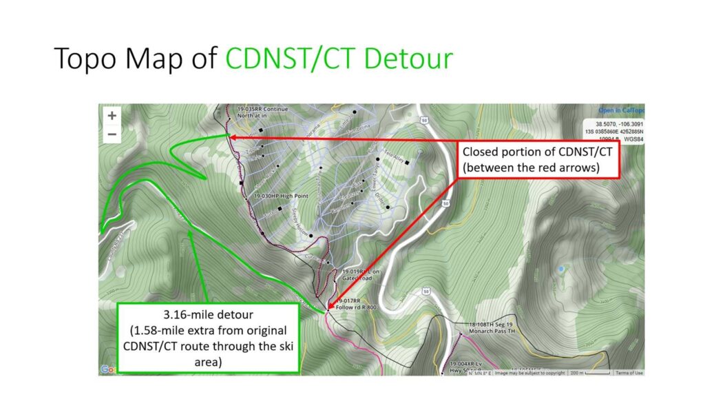
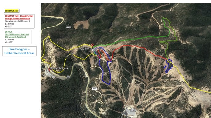
Due to the extent of this project and the concern for public safety, the CDNST and CT section through the Monarch Mountain Ski Area (CDNST- Between segments 19-017RR and 19-035RR) will temporarily involve a 3.16 mile (1.58 additional mile) detour to allow these timber removal operations to occur more safely.
The detour route will travel to the west of the ski area using a combination of the Old Monarch Pass Road and the original 1880’s wagon route over the Continental Divide, Old-Old Monarch Pass.
One polygon (near the Snowburn & Outback ski trails) designated for thinning of dead and dying Engelmann Spruce trees on the northern portion of the 2021 timber project does not allow a detour utilizing either the Old Monarch Pass Road or the Old, Old Monarch Pass route. This area includes a very short section where the CDNST travels directly through the polygon.
When active cutting and/or removal is active within this polygon, two guards will be placed. Guards may be identified by an orange vest and flag along with a Monarch Mountain name-tag. One guard will be to the north of this polygon along the CDNST/CT and one guard to the south near the intersection of Old, Old Monarch Pass and the Ski Area Boundary.
These guards will coordinate with the logging team and/or machine operators via radio to conduct traffic control with CDNST/CT users. Users should expect 15 minute delays during this time. Exact dates of the rolling closure through this polygon are TBD. The remainder of the detour (Old Monarch and Old, Old Monarch) will be utilized during the rolling closure through this single polygon.
The closure and detour will be active from July 1st-July 14th.
The closure and detour are depicted on the adjacent maps.
Detour is marked by orange flagging
For any questions, please call 719-530-5000 and ask to speak with Scott.